The night temps fell to -20C in east London

The ‘Year Without a Summer’ of 1816 brought many extremes of weather as well as a cold, wet and depressing summer.

Stats taken by Luke Howard during the February 1816 cold snap
Stats taken by Luke Howard during Feb cold snap

During the opening months frequent cold blasts brought much wintry weather. Cold weather at the end of January turned severe during the second week of February.

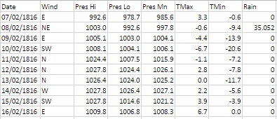
In the early hours of the 7th heavy snow, driven by gale-force north-easterly winds, brought some of the worst winter weather this area has ever seen. Some 35mm of precipitation is recorded on the 8th – this would normally give at least one foot of level snow that could obviously be whipped up into huge drifts.

Luke Howard described the scene in his diary entry saying the abundance of snow “loaded the trees to their tops and weighed down the smaller shrubs to the ground.”

The snow and polar continental air also produced perfect conditions for a textbook radiative cooling night within two days of the snowfall. The minimum recorded on the morning of the 10th: -20.6C has not, as far as I can tell, been repeated since.

annualTo put that into perspective the lowest minimum of the severe winter of 1963 for this area was -12.2C recorded at Greenwich on January 21st. The coldest night I have personally recorded was -10.3C on January 12th 1987.

Howard, who would have taken readings at his laboratory in Stratford and home in Tottenham, remarked on the rare occurrence of the cold and said that the thermometer had remained below 0F (-17.8C) for a number of hours: “an occasion that happened less than five times within a century – the last appearing to be 19 years previous.”

Howard’s theory of the day was that such extremes didn’t occur during long continued frosts but rather at an interval of one winter after such a season. He mentions the frost of 1794-95, which lasted 44 days, immediately before which the thermometer fell to -2F. The following year a low temperature of -6.5F was recorded. The year 1816 followed the cold winter of 1813/14 – the same pattern, so Howard was prepared for the night of February 9th 1816.

luke-howardModern climatologists tend to discount these old records by arguing that standard conditions set by the World Meteorological Organisation were not met. However, Howard backs up his findings with a very thorough explanation of how he went about measuring the record low temperature that followed a freezing day where the maximum thermometer didn’t rise above -6.7C.

“Early in the evening on trying the experiment of placing a wet finger on the iron railing it was found to adhere immediately and strongly to the iron. I exposed several thermometers in different situations.

“At 8 pm, a quicksilver thermometer with the bulb supported a little above the snow stood at 0F. At 11pm a spirit thermometer in the same position indicated -4F, the former which had a pretty large bulb had not sunk below -3F. At 7.30am the 10th a quicksilver and a spirit thermometer hung overnight about 8ft above the ground indicated respectively -3F and were evidently rising.

“The thermometer near the surface of the snow had fallen to 5F and probably lower, but at the usual height from the ground of my standard thermometer the temperature was at no time below -5F. The exposure is north and very open.”

Howard goes on to describe the following day:

“From 8am the thermometer continued to rise steadily at noon a temperature of 25F was pleasant by contrast to the feeling and it was easy to keep warm in walking without an upper coat. Even at 0F, however, the first impression of the air on the skin was not disagreeable; the dryness and stillness greatly tending to prevent that sudden abstraction of heat which is felt in moist and quickly flowing air.

“Early in the afternoon the wind changed all at once to SW some large cirri which had appeared all day passed to cirrocumulus and cirrostratus with obscurity to the south. I now confidently expected rain as had happened in former instances but was deceived and the thaw took place with a dry air for the most part and with several interruptions by night.

As often happens with severe cold snaps Howard reported on the 17th that the snow “was mostly gone but very thick ice remains on ponds”; a period of just over a week.

The cold snap saw the mean temperature for February 1816 over three degrees colder than average at 0.8C.

Such extreme temperatures are rare in the capital though not unheard of. I know that there have been cases of sub -20C readings in, for example, the Rickmansworth frost hollow and Ian Currie’s Chipstead Valley, but I have never seen anything so low in east London. Could it be repeated again? Possibly, but like 1816, the synoptics would have to be absolutely perfect for it to happen.

minima


Luke Howard’s old house needs saving

To many who walk down Bruce Grove, Tottenham, number 7 probably just looks like yet another old Georgian building under threat from development.

7 bruce grove
Number 7 & 8 Bruce Grove, Tottenham

Yet, if you look closely, the blue plaque says that the Grade II listed building was once the home of Luke Howard, ‘namer of clouds’.

The once grand Georgian villa was given permission to be developed over two years ago yet the developer has so far failed to begin the conversion. The building has since fallen into an alarming state of disrepair.

petetion
The petition is targeting 2,000 signatures

A petition has been set up to pressure the developer to take action before the fabric of the facade is lost forever.

Howard’s system of naming clouds is still in use today and his studies of the capital’s climate, using observations made at Tottenham and his former home in Plaistow, contributed immensely to our understanding of the urban heat island effect.

londonist article
The blue plaque was unveiled in April 2002 at a ceremony attended by the BBC Weather presenter Michael Fish and Luke Howard’s descendants

His diary entries, including accoubnts on inundations from the River Lea,  are also important in terms of our understanding on how severe weather in the early 19th century impacted London. He also had an influence on how Constable went about capturing the mood of a painting through careful cloud study

In terms of significance, Number 7 Bruce Grove is up there with 62, Camden Square, NW1, where George Symons pioneered the scientific study of rainfall, setting up the British Rainfall Organisation.

chesterton
Chesterton House, Balaam Street, Plaistow, was the home of Luke Howard in the early 1800s before he moved with his family to Bruce Grove in 1813.         Top pic: LB Newham

Too much of old London has already been lost. By reminding Redwing Estates of the importance of this small corner of Tottenham we might just help stop Howard’s former home going the same way as his Plaistow abode that was demolished to make way for an ambulance depot decades ago.

You can sign the petition at: https://you.38degrees.org.uk/petitions/save-7-bruce-grove-tottenham


Wanstead weather: 2015 review

This year finished as the ninth warmest year on record – some 0.5C cooler than 2014.monthly anomalies

Every month of 2015, apart from September, November and December, was roughly average – the means being within +/-0.7 every month, bringing the mean temperature to 11.9C, 0.7C above the 1981-2010 average.

Rainfall was less remarkable with the year being dryer than average. The total of 553mm puts it as the 162nd wettest since 1797.

It was also a very slightly duller than average year with 1,433 hours of sunshine recorded. That’s 97 per cent of average, the 77th dullest since 1881 – the least amount of sunshine for 11 years.

weather stats for 2015

For a review of each month, click January, February, March, April, May, June, July, August, September, October, November, December.

To view full stats follow this link:http://1drv.ms/1kiTuzv


December 2015: Exceptionally mild

December 2015 was a ridiculously warm month, the mildest on record in my local series going back to 1797.Top 10 warmest Dec means

The mean temperature of 10.9C is 5.3C above the average for the first winter month and breaks the previous record set in 1974 by an increadible 2.2C.

Indeed the month was warmer than what was a very mild November and was air frost free.

sahara
A persistent flow of air from the Azores was responsible for the unseasonal warmth

Sunshine was below average: 34.6hrs (86% of average) was the lowest total recorded since 2010, another December that was as exceptionally cold as this month was mild.

Rainfall was more run-of-the-mill: 44mm fell during the month: that’s 83% of average.

The warmest day occurred on the 19th with 16.3C recorded, the second warmest December day in my daily record going back to 1959 – the record fell short by just 0.1C.

warmest xmas daysOther daily records were broken including for daily mean temperature: 14.3C on Boxing Day smashed the previous record set on December 4th 1985 by 0.4C. This day also saw the highest daily minimum for December recorded: 13.5C. It was also the warmest Christmas Day on record in a series going back beyond 1852.

decrainThe lowest temperature occurred on the 8th when the mercury fell to 2.4C.

The wettest day was on the 3oth when 5.9mm of rain fell. There were only three completely dry days during the month. Thanks to the synoptic situation this area thankfully escaped the awful flooding which affected the north of England and Scotland.

december mean 1797-2015
There is quite a marked upward trend in the December mean since 1797

What has January got in store weatherwise? The models today (January 1st) suggest that low pressure will continue to pile into the UK from the west on quite southerly latitudes over the next week with some colder air infiltrating into the east and north of the UK from Europe with rain at times for our area. From that point on most output suggests largely unsettled weather continuing until the end of the two week period though there is a hint that high pressure may try to edge up from the SW or west later with less wind and rain but still mild.

Because of the exceptionally mild December there are virtually no figures I can work with to try to estimate January – but I’ll have a crack anyway, using figures that were at least 1C above the 1981-2010 December average.

A mean of about 5.2C with 59mm of rain, both around average. The highest probability is for average temps at 33% probability. Interestingly something ‘very cold’ comes in at the same probability. Rather mild and rather cold come in at 16% probability. I emphasise that even at such low probability my confidence is even lower.

My December outlook for temperature was way off – there was no chance shown of anything ‘very mild’.

Here follows the full weather diary for November. To view full stats follow this link:http://1drv.ms/1kiTuzv

1st: A few spots of rain after deluge overnight then cloudy.
2nd: Cloudy to start, some sun mid morning before it clouded over with two spots of rain. Mild overnight.
3rd: Cloudy start with little brightness all day. Rain moving in at 7.15pm and intermittent into the evening, clearing later with temp falling from midnight.
4th: Sunny, clear start, tending to cloud over at 11am with limited brightness.
5th Cloudy and windy all day – the wind peaking at 9pm but remaining fresh through the night.
6th: Cloudy and dull most of the day.
7th: Cloudy start with some light drizzle mid morning.
8th: Dull, drizzly start with steadier bursts. Heavy rain as front cleared through at 2pm. Evening and overnight much colder than of late.
9th: Sunny start, clouded over afternoon.
10th Cloudy start and through the day. Rain spreading in in the evening, clearing by midnight.
11th: Cloudy through the day until 2pm when a narrow band of rain passed through then dry and feeling cooler.
12th: Cloudy start with some drizzle around 10am.
13th: Cloudy and drizzly to start then just cloudy.
14th: Cloudy start with some brightness at noon. Cloudy into the afternoon with some drizzle overnight.
15th: Cloudy and dull. Rain later in the evening.
16th: Cloudy with two sunny intervals then cloudy with odd drizzle.
17th: Cloudy with odd brightness then rain at 5pm.
18th: Cloudy all day.
19th: Bright and breezy start.
20th: Dull start with heavy rain at 3.40pm. Then cloudy but clear by morning.
21st: Sunny start but quickly clouded over with rain.
22nd: Dull start with patchy drizzle up to 11.30am. More rain later with squall at 8pm.
23rd: Sunny start with cloud moving in then sunny spells.
24th: Sunny start quickly turned cloudy with heavy rain around noon, clearing to sunny spells.
25th: Cloudy start with light rain spreading in at 10.10am. Cloudy rest of afternoon with temperature climbing through the day for record warm Christmas day. Temp didn’t fall below 14C all night.
26th: Cloudy and warm all day. Temp fell to just 13.9C though the day then rose again to give the warmest December night on record, and also warmest December mean.
27th: Dull with brief burst of drizzle early then breezy and very mild. Clearer overnight and cooler than of late. Sunny start with pink clouds am.
28th: Sunny start with just a few cirrus. Mostly sunny through the day.
29th: Sunny start with brief heavy shower at 10.05am. Then sunny intervals.
30th Cloudy and breezy to start. Rain spreading in in the evening, stopping around midnight
31st: Sunny and clear to start but with cloud bubbling up from late morning. Brief rain after dark then dry and turning colder. Frost in early hours of 1st